
As the world celebrated the New Year of 2024, Japan was shaken by a powerful 7.5 magnitude earthquake. This surprising event during the festivities caused fear to spread. People were celebrating New Year’s around the world. Suddenly, they started thinking about Japan. They wanted to learn about Japan’s history with earthquakes. They were curious about what had happened before. The keyword “japan earthquakes history” has recently surged in popularity, drawing increased attention and curiosity on a global scale.
Scientists use different ways to measure earthquake size. One way is the Richter magnitude scale (ML). Another way is the moment magnitude scale (Mw). The surface wave magnitude scale (Ms) is older and not used as much anymore. For earthquakes predating modern measurement instruments, precise magnitude data remains elusive, rendering this list non-exhaustive.
Japan Earthquakes History: Historical Insights
People first heard about an earthquake in Yamato, now called Nara, on August 23, 416. However, the first recorded earthquake happened there on May 28, 599, during Empress Suiko’s time. This earthquake caused a lot of damage in Yamato.
There are many records of earthquakes in Japan. In 1892, a group called the Imperial Earthquake Investigation Committee started. They collected historical data about earthquakes. Later, in 1899, they published this data in a book.
After the big earthquake in Kantō in 1923, a new group called the Earthquake Research Institute took over in 1925. Nowadays, we use Tatsuo Usami’s catalogues for information about old earthquakes. His 2003 edition lists 486 earthquakes from 416 to 1888.
Quantifying Earthquakes
Firstly, Japan uses the Shindo scale to measure earthquakes. It’s similar to the scales used in the US and China. But, the Shindo scale looks at how strong the quake feels at a certain place. Unlike the Richter scale, which measures the energy at the quake’s center, the Shindo scale has ten levels. Zero means a tiny shake, and seven means a big earthquake.
Next, for Shindo five and six, the quake can feel “weak” or “strong,” depending on the damage. Lastly, quakes at Shindo four or less are mild. But, those at five or more can damage furniture, buildings, roads, and pipes.
List of earthquakes in Japan
Date and time | Magnitude | Fatalities | Epicenter | Description |
November 29, 684 (proleptic Gregorian calendar) November 26, 684 (Julian calendar) | 8.4 MK (Kawasumi scale) | 101-1,000 | The earthquake, ranging from 8.0 to 8.4 in magnitude, caused severe damage. Conflicting dates of October 14 and November 24 were reported. This period marked the Japanese acknowledgment of the connection between earthquakes and tsunamis, leading to the commencement of detailed record-keeping. Geologists continue to study these tsunami records. | |
June 5, 745 (G)
June 1, 745 (J) | 7.9 MK | N/A | Certain sources mention the earthquake taking place on June 9. | |
July 13, 869 (G)
July 9, 869 (J) | 8.9 MK | 1,000+ | The tsunami resulting from the earthquake caused significant flooding in the Sendai plain, leading to the destruction of Tagajō town. | |
May 27, 1293 (G)
May 20, 1293 (J) | 7.1 Ms | 23,024 | The earthquake near Kamakura, Kanagawa, had a magnitude estimated between 7.1 and 7.5. It may have caused a disputed tsunami, and the death toll stands at 23,024. | |
August 3, 1361 (G)
July 26, 1361 (J) | 8.4 Ms | N/A | Triggered a tsunami. | |
September 20, 1498 (G)
September 11, 1498 (J) | 8.6 MK | 31 | The earthquake struck off the coast of Nankai, Japan, around 08:00 local time on September 20, 1498, with an estimated magnitude of 8.6. It caused a significant tsunami, and while the exact death toll remains uncertain, reports indicate around 31,000 casualties. | |
January 18, 1586 | 7.9 MK | N/A | N/A | Several islands in Ise Bay are said to have vanished. |
February 3, 1605 | 7.9 MK | 5,000+ | The 1605 Keichō Nankaidō earthquake, around 20:00 local time on February 3, with a magnitude of 7.9, triggered a massive tsunami causing numerous deaths in Japan's Nankai and Tōkai regions. It's labeled a tsunami earthquake due to the disproportionately large tsunami relative to the earthquake magnitude. Uncertainty persists about whether it was a single event or two closely spaced earthquakes. | |
September 27, 1611 | 6.9 MK | 3,700+ (Official estimate) | Aizu basin, (Present day of Fukushima Prefecture) | The official estimated report indicates over 3,700 human fatalities, along with the collapse of Aizuwakamatsu Castle, numerous temples, and 20,000 houses in the affected regions. |
December 2, 1611 | 8.1 | 2,000+ | On December 2, 1611, an earthquake occurred with an epicenter off the Sanriku coast in Iwate Prefecture, registering a magnitude of 8.1M. | |
June 16, 1662 | 7.25 - 7.6 M | 700-900 | Lake Biwa south | A significant tremor is affecting the Ōmi · Wakasa area, leading to crustal deformation, including a 4.5 m (15 ft) rise in the east of Lake Suigetsu. |
1667 | 8.5 - 9.0 M | N/A | Offshore Tokachi region | An earthquake near Kushiro was deduced from tsunami deposits, likely linked to the rupture of the Kuril Trench. There are no records of the event, as the region was not yet under Japanese control at that time. |
November 4, 1677 | 8.3-8.6 Mw | 569 | Offshore Bōsō Peninsula | The quake, though low in intensity, triggered a significant tsunami, claiming 569 lives. It is believed to have ruptured the Pacific Plate-Okhotsk Plate interface at the southern end of the Japan Trench. |
December 31, 1703 | 8.0 ML | 5,233 | Edo | N/A |
October 28, 1707 | 8.6 ML | 5,000+ | Off the Kii Peninsula | It hit Nankaidō and Tōkai regions, causing widespread damage in southwestern Honshu, Shikoku, and southeastern Kyūshū. This incident also marked Mount Fuji's most recent eruption. |
April 24, 1771 | 7.4 MK | 13,486 | The 1771 Great Yaeyama Tsunami, triggered by the Yaeyama Great Earthquake on April 24 at 8 A.M., resulted in 13,486 confirmed dead or missing individuals. The devastation included 9,313 in Yaeyama Islands (8,815 in Ishigaki Island), 2,548 in Miyako Islands, and 1,625 in other areas, with over 3,000 houses destroyed. The tsunami reached over 40 m (130 ft) at Ishigaki Island and a maximum of 85.4 m (280 ft) in Miyara village. In Tarama, the estimated tsunami runup height was about 18 m (59 ft). "Tsunami stones," boulders propelled by the tsunami, can still be found in the northwestern highlands of Miyakojima. According to an unverified local legend, a small unnamed island in the area was engulfed by the tsunami and vanished. | |
May 21, 1792 | 6.4 MK | 15,448 |  Changes to the Ariake Sea coastline, in the center of Mount Unzen, Kumamoto Prefecture (right) and the Amakusa Islands (see below) were affected by the tsunami A volcanic earthquake from Mount Unzen in the Shimabara Peninsula, Nagasaki, Japan, claimed 15,000 lives. The disaster was exacerbated by a tsunami triggered by the collapse of Mount Mayuyama's southern flank into the bay. Known as 'Shimabara erupted, Higo affected,' the incident also caused casualties in Higo, Kumamoto, located 20 km (12 mi) away across the Ariake Sea, as the tsunami rebounded to strike Shimabara again. | |
December 18, 1828 | 6.9 MK | 1,559 (official confirmed) | Sanjo, Niigata Prefecture (then Echigo Province) | As per the official report, 21,134 houses and buildings sustained damage, with 1,204 of them burning down. The affected area witnessed 1,559 human fatalities and 2,666 injuries. |
December 7, 1833 | 7.5 MJMA | 150 | Shōnai, Yamagata Prefecture | A devastating tsunami, ranked among the largest in the Sea of Japan. |
May 8, 1847 | 7.3 M | 8,600+ | Nagano Basin (then Shinano Province) | In Nagano's central area, numerous structures, including Zenkōji temple, collapsed due to a powerful earthquake. The quake led to a range of disasters, including fires, landslides, and flooding caused by a makeshift "dam" formed from debris. The official report confirmed a death toll of at least 8,600 across the region. Additionally, 21,000 houses were damaged, 3,400 burned, and 44,000 homes suffered damage from landslides. |
July 9, 1854 | 7.25 MK | 995 (official confirmed) | Iga, Mie Prefecture (then Iga Province) | As per the official confirmed report, the affected area experienced damage to 2,576 houses and buildings, resulting in 995 fatalities and 994 injuries. |
December 23, 1854 | 8.4 MK | 2,000 (estimated) | Suruga Bay | N/A |
December 24, 1854 | 8.4 MK | 10,000+ | Nankai Trough | More than 10,000 people from the Tōkai region down to Kyushu lost their lives. |
November 11, 1855 | 6.9 MK | 6,641 | Edo, near the mouth of the Arakawa River | 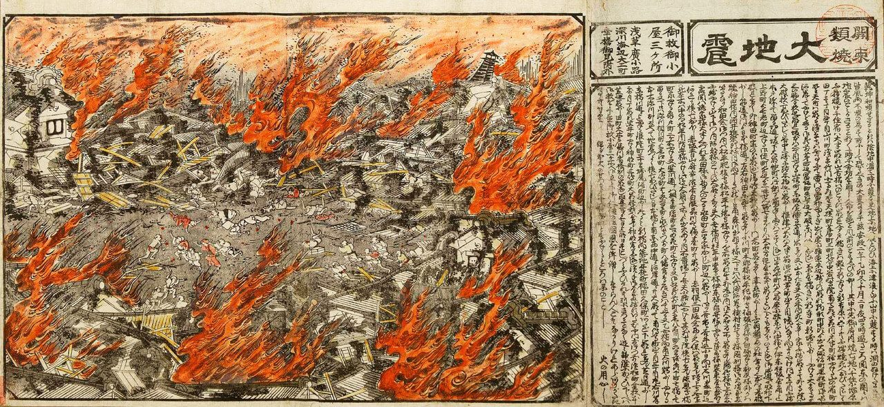 The Edo earthquake occurred in 1855. |
April 9, 1858 | 7.0 | 200-300 | Atotsugawa Fault | N/A |
March 18, 1872 | 7.1 MK | 551 (official confirmed) | off coast Hamada, Shimane Prefecture | As per the official confirmed report, the earthquake at 16:40 local time damaged 4,506 houses, led to 230 house fires, claimed 551 lives, and caused landslides that destroyed 6,567 homes in the affected area. |
February 22, 1880 | 5.5-6.0 | 0 | Yokohama City | While the damage was minor, the Seismological Society of Japan was established in response to the quake. |
July 28, 1889 | 6.3 | 20 | Tatsuda fault | This earthquake marks the first major seismic event following the establishment of the Seismological Society of Japan in 1880. |
October 28, 1891 | 8.0 ML | 7,273 | Neodani Fault | N/A |
June 20, 1894 | 6.6 ML | 31 | Tokyo Bay | The death toll was 31, with 157 injured. |
October 22, 1894 | 7.0 ML | 726 (Official confirmed) | Sakata, Yamagata Prefecture | As per the official confirmed report, the affected area witnessed damage to 14,118 houses and buildings, with 2,148 of them burning down. The toll included 726 human fatalities and 8,403 injuries. Notably, a large-scale fire erupted in Sakata, and in the Shonai plain area, there were numerous instances of cracked earth, sinking ground, sand boils, and fountains. |
June 15, 1896 | 8.5 ML | 22,000+ | N/A | This earthquake struck off the coast of Sanriku in Iwate Prefecture, triggering a 25-meter (82-foot) tsunami 35 minutes later. The tsunami devastated hundreds of houses and claimed over 22,000 lives. Its effects were also observed in Hawaii and California. |
September 1, 1923 | 8.3 ML | 142,800 | Izu Ōshima | N/A |
May 23, 1925 | 6.8 ML | 428 | Toyooka in Hyōgo Prefecture 35.6°N 134.8°E | According to the Japanese government's official report, the earthquake resulted in 428 fatalities, 1,016 injuries, the destruction of 7,863 buildings, and damage to 45,659 houses due to collapse or fire. Toyooka and the Maruyama River area suffered extensive damage. Before the shaking, intermittent cannon-like sounds were reported from the estuary near the Maruyama River. Lasting 16 seconds, the earthquake caused strong seismic vibrations in Tokyooka, collapsing many wooden buildings. Subsequent fires burned half of Toyooka, causing numerous deaths (8% of the town's population). Additionally, 272 deaths were confirmed in the Kinosaki area. |
March 7, 1927 | 7.6 ML | 3,020 | Tango Peninsula in Kyoto Prefecture | The earthquake led to the destruction of almost all houses in Mineyama (now part of Kyōtango) and was felt as far away as Tokyo and Kagoshima. |
November 26, 1930 | 7.3 Ms | 272 | Izu Peninsula | N/A |
March 3, 1933 | 8.4 Mw | 3,000+ | 290 km (180 mi) east of the city of Kamaishi, Iwate |  Depicting Kamaishi Bay in Iwate after the 1933 earthquake and tsunami. |
November 3, 1936 | 7.2 Ms | 0 | offshore Miyagi | N/A |
August 2, 1940 | 7.5 Mw | 10 | offshore Hokkaido | N/A |
September 10, 1943 | 7.2 ML | 1,083 | offshore from Ketaka District | N/A |
December 7, 1944 | 8.1 Mw | 1,223 | On December 7, 1944, at 13:35 local time (04:35 UTC), a magnitude 8.1 earthquake occurred in the Tōkai region, reaching a maximum intensity of 5 on the Shindo scale (VII on the Mercalli intensity scale). Striking the coastal provinces, it caused significant damage and generated a tsunami. The combined impact of the earthquake and tsunami resulted in 1,223 fatalities, with reported injuries affecting 20,000 people or more. | |
January 13, 1945 | 6.8 ML | 1,180 + 1,126 missing | Mikawa Bay | An earthquake occurred off Mie and Aichi prefectures, Japan, at 03:38 on January 13, 1945. |
December 20, 1946 | 8.1 Mw | 1,362 | Nankai Trough | A significant earthquake struck Nankaidō, Japan, on December 20, 1946, at 19:19 UTC. It was felt from Northern Honshū to Kyūshū. |
June 28, 1948 | 7.1 Mw | 3,769 | near Maruoka, Fukui | A major earthquake hit Fukui Prefecture, Japan, at 5:13 p.m. on June 28, 1948, during Japan Daylight Saving Time (JDT). |
March 4, 1952 | 8.1 Mw | 28 | The 1952 Hokkaido earthquake occurred around March 4, 1952, in the sea east of Hokkaido, measuring 8.1 on the Moment Magnitude Scale. Casualties resulted from the earthquake. | |
August 19, 1961 | 7.0 | 8 | One of the earthquakes named by the Japan Meteorological Agency resulted in 8 fatalities. | |
June 16, 1964 | 7.6 Mw | 26 | 50 km north of Niigata | The earthquake triggered widespread soil liquefaction in Niigata city, leading to unusually high levels of damage to buildings considering the felt intensity. |
April 1, 1968 | 7.5 Mw | 0 | Hyūga-nada Sea | N/A |
May 16, 1968 | 8.2 Mw | 52 | Offshore of Misawa, Japan | This earthquake struck off the coast of Honshu Island near Misawa, Japan, Aomori Prefecture, and was accompanied by a substantial tsunami. The event claimed 52 lives and caused significant material damage in Northern Japan. |
June 17, 1973 | 7.8 Mw | 0 | near Nemuro Peninsula | N/A |
May 9, 1974 | 6.5 Ms | 25 | near Izu Peninsula | N/A |
June 12, 1978 | 7.7 Ms | 28 | just offshore Miyagi Prefecture | The most extensive damage occurred around Sendai, and the earthquake triggered widespread landslides. |
May 26, 1983 | 7.8 Ms | 104 | off coast 50 miles (80 kilometers)from Noshiro, Akita Prefecture | With waves reaching up to 9.1 meters (30 feet) above the coastline, the tsunami generated by this earthquake was observed across a broad stretch along the Sea of Japan's coast, causing damage from Tsuruoka to Goshogawara. The tsunami claimed 100 lives, including seawall construction workers and beachgoers, resulting in a total of 104 fatalities. Soil liquefaction was widely observed throughout the affected area. |
September 14, 1984 | 6.3 Ms | 29 | Mount Ontake, Otaki, Nagano Prefecture | In total, 29 people lost their lives, and 10 were injured. |
December 17, 1987 | 6.7 Mw | 2 | 2 people killed and 146 injured. | N/A |
January 15, 1993 | 7.6 Mw | 2 | N/A | |
July 12, 1993 | 7.7 Mw | 202 | N/A | |
December 28, 1994 | 7.7 Mw | 3 | N/A | |
January 17, 1995 | 7.3 Mj | 6,434 | northern end of Awaji Island | 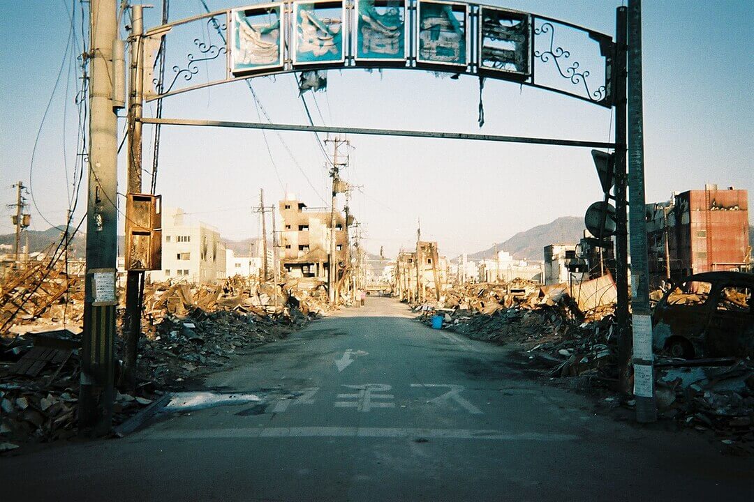 Damage in Kobe An earthquake struck Japan on Tuesday, January 17, 1995, at 05:46 JST, in the southern part of Hyōgo Prefecture. It measured Mw 6.8 on the Moment Magnitude scale (USGS) and Mj7.3 on the revised (7.2 on the old) JMA magnitude scale. Lasting approximately 20 seconds, the tremors originated 16 km (9.9 mi) beneath the epicenter, on the northern end of Awaji Island, 20 km (12 mi) away from the city of Kobe. |
May 4, 1998 | 7.5 Mw | 0 | The epicenter was in the Philippine Sea, situated far off the coast—260 km from Ishigaki Island, Japan, 400 km from Basco, Philippines, and 425 km from Hualien, Taiwan. | |
March 24, 2001 | 6.7 Mw | 2 | N/A | |
September 25, 2003 | 8.3 Mw | 1 | On September 25, 2003, an earthquake struck Hokkaido, measuring 8.3 on the Moment Magnitude scale. The event caused widespread damage to roads throughout Hokkaido, multiple power outages, and triggered landslides that further contributed to the destruction. | |
October 23, 2004 | 6.6 Mw | 68 | Ojiya, Niigata | On Saturday, October 23, 2004, at 5:56 p.m. (local time), an earthquake occurred, causing noticeable shaking across almost half of Honshū, including parts of the Tohoku, Hokuriku, Chūbu, and Kantō regions. |
March 20, 2005 | 7.0 Mw | 1 | In the Genkai Sea about 6 km (3.7 mi) northwest of Genkai Island at the mouth of Fukuoka Harbor | This earthquake hit Fukuoka Prefecture, Japan, at 10:53:40 JST on March 20 and lasted for approximately 50 seconds. |
August 16, 2005 | 7.2 Mw | 0 | about 55 km (34 mi) due east of the Oshika Peninsula in Miyagi Prefecture | N/A |
November 15, 2006 | 8.3 Mw | 0 | about 160 km (99 mi) due east of the southern tip of Simushir in the Kuril Islands | The earthquake occurred at 20:29 JST on November 15, 2006, triggering a tsunami that struck the northern coast of Japan. |
January 13, 2007 | 8.1 Mw | 0 | The earthquake occurred at 1:23 p.m. JST (04:23 UTC), prompting a tsunami warning but causing no significant damage. The epicenter was situated 95 km southeast of the 2006 Kuril Islands earthquake that struck a few weeks earlier. | |
March 25, 2007 | 6.9 Mw | 1 | about 11 km (6.8 mi) due west of the southern end of the town of Wajima | N/A |
July 16, 2007 | 6.6 Mw | 11 | about 29 km (18 mi) west of Niigata | The earthquake, a potent magnitude 6.6 event, struck at 10:13 a.m. local time (01:13 UTC) on July 16, 2007, in the northwest Niigata region of Japan. Eleven deaths and at least 1,000 injuries were reported, with 342 buildings completely destroyed, predominantly older wooden structures. |
June 14, 2008 | 6.9 Mw | 12 | about 1 km (0.62 mi) east of Narusawa Onsen in northwest Iwate Prefecture | This earthquake hit the central Tōhoku region in northeastern Honshū, Japan. |
August 11, 2009 | 6.6 Mw | 1 | 33.8°N 138.50°E, depth 20.0 km | N/A |
February 26, 2010 | 7.0 Mw | 1 | 25.902°N 128.417°E, depth 22.0 km | N/A |
December 21, 2010 | 7.4 Mw | 0 | 26.866°N 143.739°E, depth 14.9 km | N/A |
March 9, 2011 | 7.2 Mw | 0 | 38.424°N 142.836°E, depth 32 km | N/A |
March 11, 2011
05:46:23 UTC
(14:46 JST) | 9.1 Mw | 19,759 deaths, (2,553 people missing) | 38.510°N 142.792°E, depth 29 km | The megathrust earthquake, with its hypocenter off the Oshika Peninsula on the east coast of Tōhoku, stands as Japan's strongest and among the world's top five largest recorded earthquakes. The subsequent tsunami, reaching up to 40 m (130 ft) along the Sanriku coast, caused extensive casualties, material damage, and significant accidents at four major nuclear power stations. |
March 11, 2011
06:25:50 UTC | 7.1 Mw | 0 | 38.106°N 144.553°E, depth 19.7 km | "Magnitude 7.1 - Off the East Coast of Honshu, JAPAN REGION". Earthquake.usgs.gov. Archived from the original on 2011-03-17. Retrieved 2011-03-12. |
April 7, 2011
23:30:00 JST | 7.1 Mw | 4 | 38.253°N 141.640°E, depth 49 km | N/A |
April 11, 2011
17:16:13 JST | 6.6 Mw | 6 | 37.007°N 140.477°E, depth 10 km | "Magnitude 6.6 - East Honshu, JAPAN REGION". Earthquake.usgs.gov. 11 April 2011. Archived from the original on 28 July 2011. Retrieved 2011-04-30. |
July 10, 2011
10:57:12 JST | 7.0 Mw | 0 | 38.040°N 143.287°E, depth 49 km | The earthquake was centered approximately 242 km southwest of Hachijo-jima. |
January 1, 2012
14:27:54 JST | 6.8 Mw | 0 | 31.416°N 138.155°E, depth 348.5 km | The quake occurred 242 km (150 miles) southwest of Hachijo-jima, Izu Islands, Japan, and 365 km (226 miles) south of Hamamatsu, Honshu, Japan. |
December 7, 2012
17:18:24 JST | 7.3 Mw | 3 | 37.700°N 144.600°E, depth 32.0 km | The earthquake struck 293 km (182 miles) southeast of Kamaishi, Japan, and 492 km (306 miles) east-northeast of Tokyo, Japan. |
October 26, 2013
02:10:19 JST | 7.1 Mw | 0 | 37.156°N 144.661°E, 35.0 km depth | N/A |
November 22, 2014
22:08:18 JST | 6.2 Mw6.7 MJMA | N/A | 36.641°N 137.888°E 9.0 km depth | The earthquake caused injuries to 41 people and impacted the entire Chubu region. Numerous surface ruptures, primarily near Hakuba Village, were also generated by the quake. |
May 30, 2015
20:23:02 JST | 7.8 Mw | 0 | 27.831°N 140.493°E, depth 677.6 km | The earthquake occurred 189 km (117 miles) west-northwest of Chichijima, Japan. |
April 14, 2016
21:26:39 JST | 6.2 Mw | 9 | depth 10.0 km | The earthquake struck 7 km (4.34 miles) southwest of Ueki, Kumamoto Prefecture, Japan. |
April 16, 2016
01:25:06 JST | 7.0 Mw | 41 | 32.791°N 130.754°E, depth 10.0 km | The earthquake occurred 1 km (0.62 miles) east of Kumamoto, Japan. |
November 22, 2016
05:59:49 JST | 6.9 Mw | 0 | 37.392°N 141.403°E, 11.4 km depth | The earthquake was located 37 km east-southeast of Namie, Fukushima. |
June 18, 2018
07:58:35 JST | 5.5 Mw | 4 | 34.834°N 135.606°E, 13.2 km depth | The earthquake occurred 2 km north-northwest of Hirakata, Osaka. |
September 6, 2018
03:07:59 JST | 6.6 Mw | 41 | 42.671°N 141.933°E, 33.4 km depth | The earthquake was located 27 km east of Tomakomai, Hokkaido, Japan. |
June 19, 2019
22:22:19 JST | 6.4 Mw | 0 | 38.635°N 139.4543°E, 16.1 km depth | The earthquake struck 33 km west-southwest of Tsuruoka. |
February 13, 2021
23:07:49 JST | 7.1 Mw | 1 | 37.702°N 141.762°E 55 km depth | The earthquake occurred 2 km east-northeast of Ishinomaki. |
March 20, 2021
18:09:45 JST | 7.0 Mw | 0 | 38.475°N 141.607°E 54 km depth | The earthquake struck 27 km east-northeast of Ishinomaki. |
October 7, 2021
22:41:24 JST | 5.9 MW | 0 | 35.577°N 140.070°E 80 km depth | The earthquake occurred 4 km southwest of Chiba. |
March 16, 2022
23:36:30 JST | 7.3 MW | 4 | 37.702°N 141.587°E 63.1 km depth | The earthquake was located 57 km east-northeast of Namie. |
May 5, 2023
14:42:04 JST | 6.2 Mw | 1 | 37.540°N 137.305°E 8.7 km depth | The earthquake occurred 49 km northeast of Anamizu. |
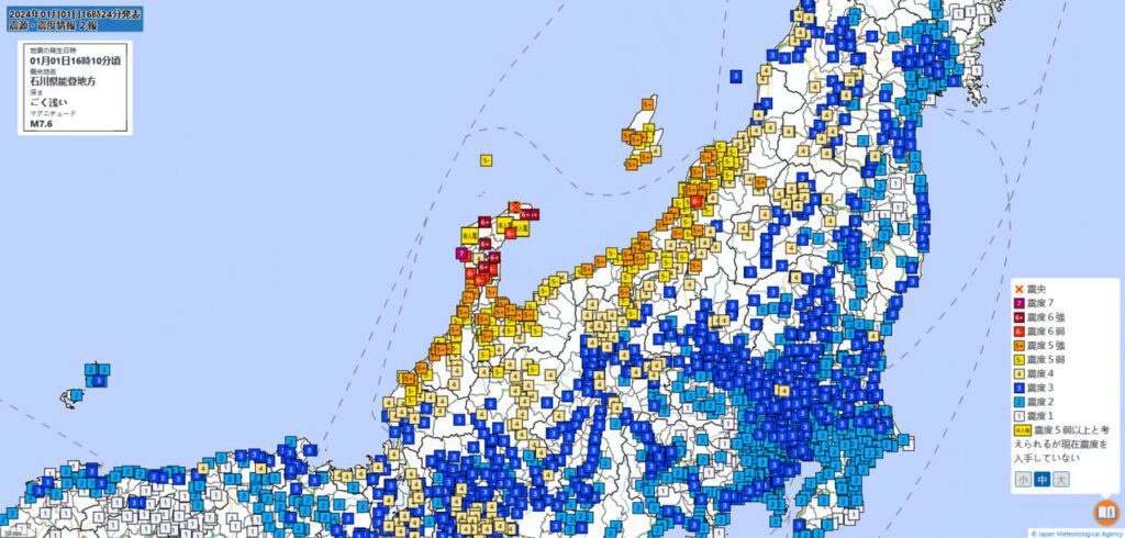
January 1, 2024
16:10:09 JST | 7.5 Mw | 126 deaths (210 people missing) | 37.498°N 137.242°E 10.0 km depth | The earthquake struck 42 km northeast of Anamizu. |
Information updated January 8, 2024
At January 1, 2024, at 4:10 PM, a big earthquake hit near Toyama. It was 7.5 on the Richter scale and 89 km north of the city. Secondly, the quake was about 10 km deep. It affected an area where over six million people live within 200 km of the center. Next, in the following days, there were many smaller quakes, or aftershocks. In fact, 59 of them were above 2.5 on the scale. Lastly, the biggest aftershock was a 6.2. These intense seismic events are uncommon, marking the strongest earthquake in Japan since the historic 2011 earthquake.
After the big earthquake in Ishikawa on New Year’s Day, the Weather Agency warned of more strong shakes for a month. At the same time, the number of missing people jumped from 103 to 323. But, the local government is still looking for them, knowing some might have moved and are safe but out of touch.
The earthquake deaths rose to at least 168, and cold weather with snow made rescue work harder. Both Wajima and Suzu cities had 70 deaths each, according to reports.
The earthquake was a big one, with a magnitude of 7.6. It caused tsunamis, buildings to fall, and a huge fire in Wajima. This caused a lot of damage to the Noto Peninsula in Ishikawa.

Continued Aftershocks Pose Ongoing Threat in Japan
Many aftershocks, some as strong as 5 on the Japanese scale, kept shaking the area. The Weather Agency said these shakes will continue for some time.
“Even though earthquakes are happening less often, there are still more than after the 2004 Niigata-Chuetsu and 2016 Kumamoto quakes,” said agency official Shinya Tsukada.
Tsukada said it’s less likely we’ll have another big quake like on New Year’s Day, but reminded us that “earthquakes are still happening.”
“Stay alert for strong earthquakes of 5 or higher in the next month,” he added.
Simultaneously, snowstorms have compounded the challenges of the relief operation, even though the peak of heavy snowfall has subsided for the Noto Peninsula. Authorities issued warnings about plummeting temperatures, highlighting the potential for further structural collapses in buildings already rendered precarious by the forceful quake and subsequent aftershocks.
Landslides and Isolation Hinder Relief Efforts in Anamizu Following New Year’s Day Quake
On New Year’s Day, a big earthquake caused a landslide in Anamizu. This sad event led to the death of seven people on Sunday. This added to the already tragic loss of 14 people from two houses. The risk of more landslides increased because of rain and snow. Some places even had more than 10 centimeters of snow. This made it harder for the rescue teams to reach some remote areas by car.
The earthquake and about 1,000 landslides in the Noto area damaged roads. This left over 3,300 people in 24 different areas of towns and cities cut off from help.
To help these people, small groups of Self-Defense Force soldiers walked to these cut-off areas. They brought aid and helped the people who were stuck there to leave. The Defense Ministry released a video showing this.
Helicopters from the military, police, and fire department were sent to the areas affected by the disaster. On Monday, the Defense Ministry increased the number of troops helping out to 6,100. They also used nine ships and 40 planes. Police and firefighters from all over the country were sent to help too.
The Weather Agency warned people about the cold weather. This was important because about 18,000 homes didn’t have electricity on Monday afternoon. According to officials in Ishikawa, over 28,000 people were staying in about 400 shelters in the area.
On Monday, a gym in Kanazawa started to let people in. They had 250 tents and could take in 500 people. They let in people who needed help the most first, like old people and pregnant women. These people will stay there until they can find them other places to stay, like hotels.


